en
en
The onset of Russia’s full-scale invasion of Ukraine in February 2022 turned every Ukrainian’s life upside down. Whether fighting the enemy on the front lines or working to accelerate victory from the rear, we all need up-to-date information about the frontline. For Ukrainians, the Deep State War Map has become a source of such knowledge — simple, clear, current, and reliable.
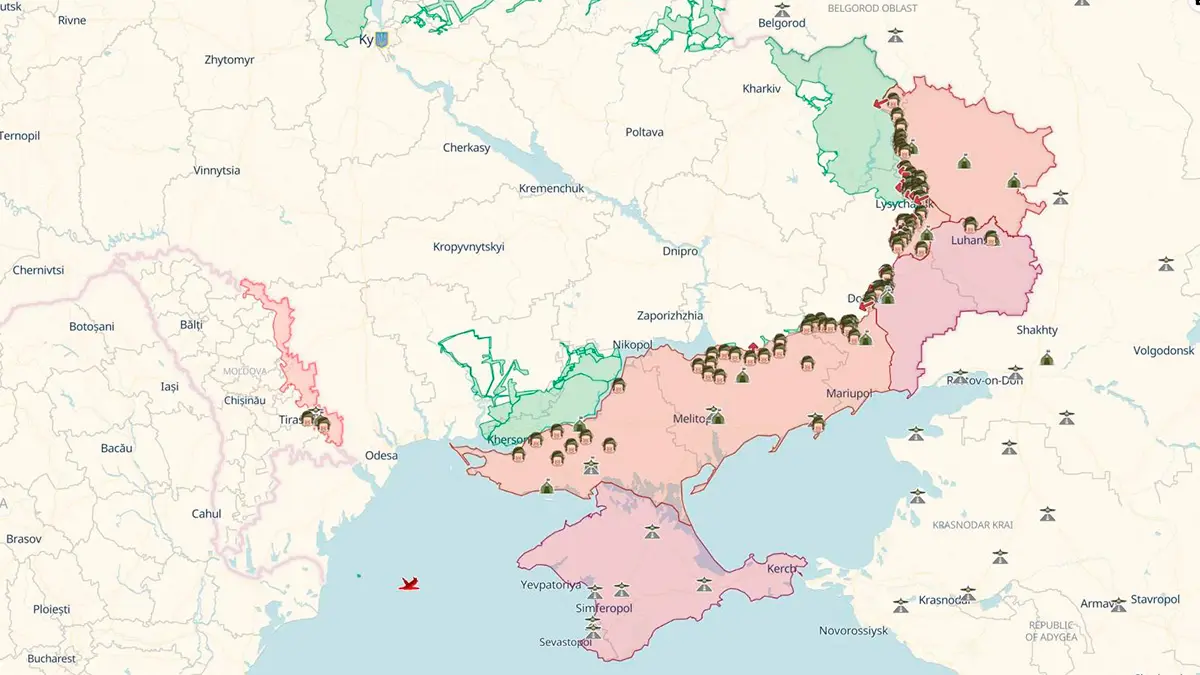
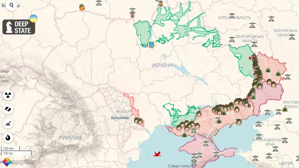
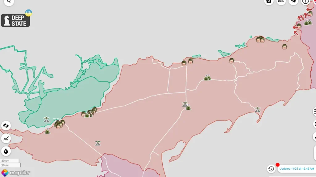
Current Deep State War Map Online
How the Deep State Ukraine War Map Was Created
The Telegram channel Deep State under this name has existed since February 2020. It published news on international geopolitics and Ukraine, along with analytical materials. When Russian troops began massing at our borders and conducting suspicious maneuvers, the channel focused more on this threat. Information on troop movements, numbers, and international reactions to these hostile actions was shared.
When the enemy launched military actions in Ukraine on February 24, 2022, the project team decided to share the available information. The most convenient way was through a map, making it immediately clear where things were happening. Russians initially published a lot of materials with geolocation. This data was collected, processed, and marked on an interactive map based on GoogleMaps.
Unfortunately, the first maps depicting the tragic events of the early days of the war did not survive. GoogleMaps blocked the project, likely due to numerous complaints from Russians. Therefore, the Deep State team decided to create an independent website so the war map would be accessible to everyone and not dependent on anyone. Thus, the Deep State war map in its current form appeared in early April.
Deep State Map Markers
The main markers on the map include:
- Liberated territories;
- Territories liberated in the last two weeks;
- Occupied territories, including outside Ukraine;
- Enemy units;
- Enemy headquarters;
- Enemy airfields;
- Enemy attack directions;
- Railways.
Features of the Deep State War Map
The main advantages of the Ukraine war map are its relevance and informativeness. Deep State offers various features and useful functions, such as:
- Event Visualization. The Deep State map shows where battles are happening in Ukraine and the positions of Russian troops.
- Tracking Changes. The war map in Ukraine is regularly updated based on information from open sources such as news reports, social media posts, and surveillance camera footage. The calendar at the bottom of the page allows users to “rewind time” and see how the situation has changed.
- Analysis Tools. The Deep State war map provides simple tools for analyzing the situation, such as measuring distances or plotting routes. However, it cautions against using the map to choose safe paths due to the dynamic battlefield.
- Flexible Settings. Users can choose their preferred map type — standard, topographic, or satellite view. They can also select the appearance of markers and the data displayed.
- Interesting Additional Features. Deep State map allows users to measure the range of various artillery systems, simulate a nuclear strike, view enemy fortifications, and more.
- Mobile App. The Deep State Map mobile app allows users to access the map from anywhere.
Deep State War Map, Issues, and Challenges – Video
Who better to tell the story of Deep State than its founders and creators? Watch this interview with map authors Roman Pohorilyi and Ruslan Mykula about the project’s history and the plans of these ambitious young people:
Conclusions
The online Deep State war map has become one of the most important sources of information about the war in Ukraine. It is valued for its relevance and reliability. The map allows users to view troop placements, conflict zones, and analyze the frontline dynamics. It is used not only by ordinary citizens but also by journalists, military experts, and others.
Frequently Asked Questions about Deep State
The exact number of people involved can vary. It includes specialists—programmers, OSINT experts, administrators—and a large number of volunteers who help search for and process news.
All information is sourced from various channels – news, numerous internet publications, local residents, or military personnel.
Yes, any user can propose news to the Deep State site administration. It will be used only after thorough verification.
Currently, the Deep State map is available in Ukrainian and English.
The primary source of funding for the Deep State project is user donations. You can support the project by making a voluntary contribution through official channels like the DeepStateMap website or their social media accounts. This helps the team continue their work and maintain the map’s relevance.
The Deep State war map visualizing the conflict in Ukraine is available to all internet users.